
Rolta GeoCAD is an advanced Computer Aided Dispatch product designed and developed for public safety agencies viz. Police, Fire, Medical and other emergency response agencies. It has all the capabilities required for automated call taking, dispatching, vehicle tracking, overall supervision and reporting. Rolta GeoCAD has seamless integration with various technologies like GIS, GPS, GPRS, Radio and advanced telecom technologies. It provides a fully functional emergency response system.
Rolta GeoCAD Product
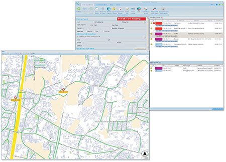
Rolta GeoCAD Desktop: It provides the capabilities required for call takers, dispatchers and supervisors for emergency response management. It has an intuitive GIS interface that allows the emergency response agencies to record, locate, and respond to distress alls within a spatially enabled environment. The Call Taker module has an interface for capturing the event information received from the caller, record the event and communicate to Dispatchers. The Dispatcher module supports advanced dispatching capabilities like “Nearest vehicle” recommendation and “shortest path” calculation, thereby enabling a quick response. It also provides the supervisor an interface to monitor the activities of the entire call taking and dispatching system, analysis and reporting.

Rolta GeoCAD Web: It is based on standard web technology that enables the users to view the complete event information and response vehicles in their current geographic position. It also provides an enhanced management reporting software suite to provide multiple reports from basic call taking reports to advanced analytical reports that enable senior officials or supervisors to get a Bird’s-Eye view on the current situation. Advanced reports like chronological reports, resource utilization reports, summary reports with graphical presentation are also supported by Rolta GeoCAD Web.

Rolta GeoCAD Mobile: It provides access to detailed information regarding the event to the responding units. The responders can also update the Control Center about the progress of the event thereby enabling better coordination between the responding units and the Control Center.

Key Features
- Multi-Agencies Support
- Multi-Language Support
- Single Console Operator
- User Friendly GUI
- Dispatch Decision Support
- Reports & Analysis
- Unified Communication System
- Integrated Mobile Data Terminal & Smart Phones.
- CCTV Integration
- 3D Map support
Rolta GeoCAD Desktop
Call taker
- Customizable & easy to use GUI.
- EPABX integrated call taking capability.
- Ensures complete data collection using “questionnaire” based on event type.
- Forms based input screen for fast data entry.
- “Smart Addressing system” for faster incident location.
- Automatic caller address input via ALI/ANI.
- Reduced duplicate calls by “Nearby Location” & “Appended Events”.
- Voice recording capabilities through “Voice Logger”.
- “Messaging” capability between call takers, dispatchers and supervisors.
Dispatcher
- Automatic event routing to appropriate dispatcher.
- Quick response & dispatch using Nearest vehicle
- Shortest Route between vehicle & incident computation
- Supports Resource & Response planning
- Time stamping and recording vehicle & incident information
- Event Monitoring till closure
- System suggested response plan based on type, location and time of the event
- Facility to dynamic resource search
- Route Planning and Task Management
- Integration with CCTV for realtime situational awareness & Decision support
Supervisor Functionalities
- Capability to configure the daily operational needs of the command center.
- “Add” and “edit” or “Delete” Event Types and Sub Types and generate report module.
Operating System
- Microsoft Windows 2008 Enterprise or above for Servers.
- Microsoft Windows XP or above for Desktop Clients & MDT.
- Windows Mobile 6.5 or higher for PDA & Handheld devices.
Rolta GeoCAD Web
- Supports access from anywhere on the Internet / Intranet on any standard browser.
- Dashboard, Analysis chart & “Event view” provides a Birds-Eye view on the situation.
- “Fleet Monitoring” allows display of vehicle locations in their correct geographic position on the map.
- Enables user to perform specialized analysis and generate custom reports.
- Geofence and Route deviation alerts.
Rolta GeoCAD Mobile
- Supports PDA, MDT & Handheld devices.
- Presents complete information of the event assigned in a comprehensible User Interface.
- Enables generation of the pre-defined status messages for transmission to command center.
- Enables the Mobile Workforce to provide information to the Command Center such as text messages and incident closing reports.
- Fully integrated “maps”.
- Automatic real-time GPS location and display on map.
- Support for online as well as offline mode
![]()
For more information,
Web: www.rolta.com